A Two Egg TV Page. See more at https://twoeggtv.com.
Showing posts with label red stick creeks. Show all posts

Tuesday, November 19, 2019

They'd cry out I was a savage: Neamathla stands against the U.S. Army

Neamathla, General Gaines, and Washington Irving!

by Dale Cox

Neamathla (Eneah Emathla)
Primary Chief of Fowltown
Note: As we approach the Scott 1817 Seminole War Battle Reenactment, which will take place on Dec. 6-8 in Chattahoochee, Florida, I will post articles that give you information about the significance of that encounter. DC

The effective strengths of the Fourth and Seventh Infantry Regiments of the U.S. Army began arriving at Fort Scott on today's Lake Seminole in Southwest Georgia 202 years ago today. The soldiers did not know it, but they were coming to start a war.

Maj. Gen. Edmund P. Gaines, a hero of the War of 1812, commanded the march, which started at Camp or Fort Montgomery in the Tensaw settlement of what is now Alabama. He was under orders from the administration of President James Monroe to kidnap the Red Stick Creek chief Neamathla (Eneah Emathla) and some of his leading men. 

Neamathla was the principal chief of Fowltown, a Lower Creek village that had recently resettled on the swamps of Four Mile Creek about 3-4 miles south of present-day Bainbridge, Georgia. He and his followers sided with the Prophet Josiah Francis during the Creek War of 1813-1814 but were defeated at the Battle of Uchee Creek and forced to evacuate to the Florida borderlands. 

Rearmed by the British during the closing months of the War of 1812, they refused to evacuate their lands as required by the Treaty of Fort Jackson, which seized more than 22 million acres from the Creeks. Neamathla had not signed that document. "The land is mine," he told Maj. David E. Twiggs of the U.S. Army that summer, "I am directed by the Powers Above to defend it."

Maj. Gen. Edmund P. Gaines, USA
Photographed later in life.
National Archives.
Angered by the chief's "defiance," the powers in Washington, DC, instructed Gen. Gaines to hold the chief as a hostage until his followers left the Fort Jackson Treaty lands. The general started his troops for Fort Scott.

Hindsight shows that everyone involved in the U.S. side of the dispute - from subordinate officers at the fort on the Flint to the highest officials in the Monroe Administration - underestimated Neamathla. The fighting that would take place at Fowltown and on the Apalachicola River over the next eleven days would show by how much.

Perhaps the best account of the chief was written by the famed author Washington Irving. Remembered today for The Legend of Sleepy Hollow and other works, Irving interviewed Florida Gov. William P. Duval about his later interactions with the chief. Duval met Neamathla as lands were being selected for Florida’s capital city of Tallahassee:

…He was a remarkable man; upward of sixty years of age, about six feet high, with a fine eye, and a strongly-marked countenance, over which he possessed great command. His hatred of white men appeared to be mixed with contempt: on the common people, he looked down with infinite scorn. He seemed unwilling to acknowledge any superiority of rank or dignity in Governor Duval, claiming to associate with him on terms of equality as two great chieftains.[i]

Washington Irving, the noted American
writer who penned a fascinating account
of Neamathla.
Library of Congress.
Irving’s statement that the chief was unwilling to acknowledge the superiority of the white governor is powerful. It shows that Neamathla regarded himself as the equal of any white leader. He also left no doubt about his feelings concerning the U.S. occupation of his lands:

…This country belongs to the red man; and if I had the number of warriors at my command that this nation once had, I would not leave a white man on my lands. I would exterminate the whole. I can say this to you, for you can understand me: you are a man; but I would not say it to your people. They’d cry out I was a savage, and would take my life. They cannot appreciate the feelings of a man that loves his country.[ii]

Duval was attempting to arrange the movement of Neamathla and his followers from a village site at Tallahassee to a new reservation established for them near the Ochlockonee River in Gadsden County, Florida. The chief’s voice grew louder and louder until it could be heard over the entire village as he made clear that he was willing to fight to the death to defend the lands of his people:

…He held in his hand a long knife, with which he had been rasping tobacco; this he kept flourishing backward and forward, as he talked, by way of giving effect to his words, brandishing it at times within an inch of the governor’s throat. He concluded his tirade by repeating, that the country belonged to the red men, and that sooner than give it up, his bones and the bones of his people should bleach upon its soil.[iii]

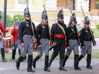
Pensacola's Jacksonian Guard demonstrates the uniforms,
weapons and musical instruments of the 4th and 7th
Regiments. The unit will participate in the Scott 1817
Reenactment at Chattahoochee, FL on Dec. 6-8, 2019.
Neamathla eventually did put his words into action. He never occupied the tiny reservation established for him in Florida but instead moved up the Chattahoochee River to the surviving part of the Creek Nation. There he became the principal chief of Hitchiti and emerged as one of the principal leaders in the Creek War of 1836.

Captured by U.S. and Alabama militia troops, he was placed in chains and marched west on the Trail of Tears. An officer who saw him wrote that the chief was over 80 years old but never uttered a complaint despite the weight of his chains. He reached what is now Oklahoma during the brutal winter of 1836-1837. One of the final mentions of him to appear in U.S. Army records is a plea for his people to receive the blankets that they had been promised. They were suffering in the snow and ice and had nothing with which to cover themselves.  

Editor's Note: The events of November 1817 are commemorated by the annual Scott 1817 Seminole War Battle Reenactment at Chattahoochee, Florida. This year's event is scheduled for December 6-8 and will feature an Education Day for school and home school students on Friday, December 6, followed by public days on Saturday and Sunday, December 7 and 8. Activities take place at River Landing Park and feature living history encampments, demonstrations, exhibits, a mobile museum, the authentic 19th-century replica keelboat Aux Arc ("Ozark"), and battle reenactments on both Saturday and Sunday. All activities are free to the public.

For more information, please visit https://scott1817.com. This video will give you a quick 30-second preview:


[i] Washington Irving, “Conspiracy of Neamathla” in The Works of Washington Irving, Author’s Revised Edition, Volume XVI, Wolfert's Roost, New York, G.P. Putnam, 1863, page 297.
[ii] Ibid., pp. 297-298.
[iii] Ibid., pp. 301-302.
Wednesday, November 2, 2016

Map reveals details of Jackson County's Native American population

Portion of the Woodbine Map of 1814
showing what is now eastern
Jackson County, Florida
National Archives of Great Britain
(Click to Enlarge)
A newly discovered map from the National Archives of Great Britain is proving an incredible view of the Native American groups living in what is now Jackson County at the end of the Creek War of 1813-1814.

The map is believed to have been drawn by a British officer, Capt. George Woodbine, who arrived at Apalachicola Bay on May 10, 1815. His orders were to recruit and train an auxiliary force of Seminole, Red Stick Creek and maroon (escaped slave) warriors that could assist in coming British movements against the Gulf Coast.

Woodbine established himself twenty miles up the Apalachicola River at Prospect Bluff, where John Forbes & Company had a trading post and where the British would soon build a powerful fort. He moved from there up the Apalachicola and Chattahoochee Rivers as far as present-day Eufaula, Alabama. He met with chiefs and principal men at each village that he encountered, hoping to obtain their support for the British cause in the War of 1812.

The newly discovered map appears to have been drawn by Woodbine as he made his way upriver. It reveals an incredible amount of new information about Native American and maroon populations on the Apalachicola and Chattahoochee Rivers in 1814. This was a critical moment in history due to the sudden arrival in the area of thousands of Red Stick Creeks who had been driven from their homeland by American armies. Woodbine's arrival on the Apalachicola came less than six weeks after the devastating defeat of the main Red Stick army at the Battle of Horseshoe Bend, Alabama.

Red Stick Creek refugees were flooding into West Florida where they hoped to obtain food and protection from the Spanish who then controlled the province. Woodbine's map shows that several previously unknown groups of Creeks were establishing camps along the eastern border of what is now Jackson County during the time of this tragic migration.

Neals Landing Park, site of the Creek Indian town of
Ekanachatte ("Red Ground"), in Jackson County, Florida.
Looking at the map from top to bottom, it shows Irwin's Mill Creek flowing into the Chattahoochee River from the northwest just above the site of today's Neal's Landing. The village of Ekanachatte or "Red Ground" had been established here in the 1760s and was a well-known and prosperous town by 1814. It was the home of the chief Econchattimico ("Red Ground King") who had succeeded his uncle, Cockee, who was also known as "the Bully" for his abilities as a trader.

Moving down the river, the map shows small symbols for Creek settlements on the river just out from the area of today's Buena Vista Landing. Small springs in this vicinity made it a logical place for refugee camps.

At the northern end of today's Apalachee Wildlife Management Area can be seen a "Tallasee Town." Tallasee was a well known town on the Tallapoosa River from which Peter McQueen and other chiefs had joined the Red Stick movement. The settlement shown as "Tallasee Town" on Woodbine's map was undoubtedly occupied by refugees driven from their homes in the Creek Nation.

Immediately below Tallasee Town is seen Fowl Town, also a settlement of refugee Red Sticks. Led by Neamathla (Eneah Emathla) this settlement occupied both sides of the river with the main town being on the eastern or Georgia shore. This settlement was established in the winter of 1813-1814 after Neamathla and his warriors were defeated by William McIntosh and the white-allied Coweta warriors at the Battle of Uchee Creek below present-day Phenix City, Alabama. The Fowl Town people did not remain at this site for long but with a couple of years moved over to a new location near Bainbridge, Georgia.

To the southwest of Fowl Town is a settlement of people from the "Euchee Tribe." A band of the Yuchi (or Euchee) led by their chief Billy had been part of the Red Stick force at the Battle of Uchee Creek. They came downriver to what is now Jackson County where they lived until 1817.

Neamathla (Eneah Emathla)
Chief of Fowl Town in 1814-1818.
Downstream below Fowl Town and at a site now submerged beneath Lake Seminole can be seen a settlement that was built on both sides of the river and called "Saokulo Tribe." These may have been Sawokli refugees who had gone against most of the other Lower Creeks and joined the Red Stick movement with the Fowl Town and Euchee bands. Their presence so near the forks of the Chattahoochee and Flint Rivers is interesting as they were living in the vicinity when they were first encountered by the Spanish during the 1600s.

At another site now beneath the waters of Lake Seminole can be seen a village of Oketee Ockane (Okitiyakani) people. These were undoubtedly Red Stick refugees from a much larger town of the same name located higher up the Chattahoochee River. Most of the town's people stayed neutral in the Creek War or fought on the side of the United States, but some joined the Red Stick forces that tried to overthrow the traditional leaders of the Creek Nation and had to flee for their lives down into the Spanish borderlands.

Finally, just above the confluence of the Chattahoochee and Flint Rivers, can be seen the towns of the "Tochtohule Tribe." These were the Tocktoethla villages of Thomas and William Perryman, long-time residents of the region. The former, who lived on the Georgia side of the river, was the principal leader of the Seminoles at the time. The latter lived on the west bank in what is now Jackson County. Both of the sites shown on the map are now beneath Lake Seminole.

The Woodbine map adds a great deal of new information to our knowledge about what was happening in the Chattahoochee River region of Jackson County. A large number of Red Stick refugees had suddenly appeared there, placing a great strain on the more established towns such as Ekanachatte and Tocktoethla. The refugees were starving and, as the British soon reported, were digging up seed corn to eat as fast as it could be planted.

The groups and villages shown on the map all joined the British cause during the War of 1812 and were closely associated with the British Post at Prospect Bluff ("Negro Fort") and the forward base called Nicolls' Outpost at what is now Chattahoochee. Many relocated completely to Prospect Bluff over the coming winter, while others remained on the lower Chattahoochee River.

Please click here to read the next article about the map.

Please click here to learn more about the British presence on the Apalachicola River in 1814-1815.