A Two Egg TV Page. See more at https://twoeggtv.com.
Showing posts with label chattahoochee river. Show all posts

Wednesday, October 30, 2019

The Witch of Buena Vista Slough

A Haunting near Buena Vista Landing

by Dale Cox

A bizarre series of events along Buena Vista Slough (then called Sugar Mill Creek) terrified residents in Florida's Chattahoochee River valley more than 140 years ago.

October 1877 was a time of growing optimism in eastern Jackson County. The violence and strife of Reconstruction were finally over, the local economy was improving, and riverboat traffic was once again booming on the Chattahoochee River. Sugar Mill Creek flowed from a collection of small springs past the remains of the already ruined mill that gave the stream its name to join the river near today's Parramore Landing.

The lands along its low ridges were well-suited for the production of cotton, corn, tobacco, and other crops, and the harvest was good that fall. Most of the farms were small, and the families who settled near the creek in the years after the Civil War included whites, blacks, and Native Americans. All worked the land or cut timber to make their livings.

Things seemed peaceful as everyone worked and waited for the first cold snap of winter and "hog killing" time. No one, however, expected what happened next:

Buena Vista Slough now covers the original Sugar Mill Creek.
A Witch! The people about Sugar Mill creek in east Jackson are all alarmed about a witching at Godwin's spring on Thursday night last. Highsmith, an elderly Negro man, says his family was asleep by the fire when an unseen witch started to pelt his cabin with stones and brickbats. Thinking it was irreverent pranksters or Republicans he took up his shotgun and rushed into the yard only to witness a piece of lime rock rise from the ground and dash itself against his chimney. - Marianna Courier, October 1877. 

Godwin's Spring, where the incident supposedly took place, is now underwater at Godwin Lake, the head of the slough that extends north from Buena Vista Landing on the backwaters of Lake Seminole. The spring and the small creek that it and a few other springs headed was inundated when the Jim Woodruff Dam was completed in 1958.

Buena Vista Landing as seen from the slough.
Stories of witches or other unseen forces that threw rocks, bricks, and other objects against the sides of houses were relatively common in the 19th century. The best-documented case was the Edgefield Ghost in South Carolina, but the best-known was, without doubt, the Bell Witch of Tennessee.

People in that day usually blamed such instances on witches, although today they are often said to be the result of "poltergeist" activity.

More from the Witch! A witch seems quite begrudged with the people above Bellview on Sugar Mill creek. Brickbats, rocks, crockery and tools fly about. Dogs howl without ceasing. Bells sound at midnight. The rattle of dragging chains distinctly heard. Birds that speak. A creature like a dog with the head of a cat! If but half the stories are true then the good citizens of that vicinity had best revisit the methods of Cotton Mather of old Salem! - Marianna Courier, October 1877

The two brief articles are the only known written accounts of the paranormal "outbreak" that shook the Buena Vista area of eastern Jackson County in 1877. Earlier generations had vague memories of the incidents and told of how their parents and grandparents met for weekend-long brush arbor "preachings" and "camp meetings."

Like the Edgefield and Bell Witchings of earlier generations, this one also slowly faded away.


Sunday, September 8, 2019

Massive diamond buried in Jackson County, Florida?

A dream of buried treasure!


by Dale Cox

Site of the treasure dig.
Jackson County is the only Florida county to touch two other states. Perhaps its location - where Florida borders both Alabama and Georgia - makes it a focal point for legends. Whatever the reason the county has more than its share of buried treasure stories.

The tale of the Money Pond is perhaps the most famous. Legend holds that Native American warriors dumped a fabulous treasure of gold and silver into a swamp in the northeastern part of the county to save it from Andrew Jackson's soldiers. Other alleged treasures include one near Little Zion Road north of Sneads and a rumored cache of Confederate gold.

One of the strangest stories, however, emerged from a dream:

Your correspondent has been favored with the facts of a most wonderful dream. The dreamer, Mr. Hardy Lewis of Decatur county, Ga., has for the past seven years dreamed of finding gold and a large diamond buried on the bank of the Chattahoochee river. - Letter dated "Neal's Landing, Fla., May 3," Columbus Enquirer, May 6, 1881.

Chattahoochee River at Neals Landing, Florida.
Mr. Lewis was described as a "highly respected citizen of Decatur county" and regularly told neighbors about his repetitive dream. They still must have been surprised, however, when he announced that his dreams had finally revealed the date on which he would find the treasure: May 5, 1881.

The man was absolutely convinced that his dreams were directing him to the fortune of a lifetime. He prepared supplies, tools, and helpers for a dig and headed for the banks of the Chattahoochee River on May 1, 1881:

...Being so much impressed by such an innocent dream he resolved to go to the spot and try the virtue of his visionary wondering. He came to the river opposite Neal's landing and recognized instantly the place where his treasure was buried, although this was his first visit. He has been digging two days, but states he will not find the object of his search until May 5th. - Ibid.

Lewis's dream was particular as to the value of the treasure. It consisted, he said, of a diamond "valued at $24,000" as well as a large quantity of gold. Taking inflation into account, a diamond worth $24,000 in 1881 would be worth $603,696.47 today.

Fine quality rough or uncut diamonds are difficult to price but currently sell for around $2,600 per carat. Assuming the diamond is of fine quality - and surely a dream diamond would be - then it would weigh 232 carats.

Another view of the Chattahoochee River at Neal's Landing.
The fallen tree was toppled by Hurricane Michael.
The dig took place in the riverbank between Neal's Landing and the mouth of Irwin's Mill Creek on the Jackson County side of the Chattahoochee River. The work was followed with great interest by residents of the area:

...At the time of this writing the digging is still going on, Mr. Lewis is an old and highly respected citizen of Decatur county, and the result of his excavation is awaited, by a large number, with much anxiety. - Ibid.

May 5 came and went, however, with no trace of the diamond or its accompanying gold. The search ended in failure, and all that survives as a reminder that it ever happened is a shallow depression in the riverbank.

In this era, when dreams no longer hold the significance that they did in the late 1800s, it is easy to smile and disregard the treasure hunt as foolishness. Doing so might be foolish as well.

The interpretive sign at Neals Landing survived Hurricane
Michael, while trees all around it were toppled.
The very spot selected by Lewis for his dig is within feet of the point where the paddlewheel steamboat Eagle caught fire and ran aground in 1854. The boat was carrying a season's worth of cotton money from Columbus, Georgia, down to Apalachicola, Florida, so it could be sent by ocean-going vessel to banks in New York. 

The value of the gold shipment in modern terms? $3,048,714.29.

Some of the money was recovered shortly after the wreck of the Eagle, but much of it remains buried beneath a 165-year accumulation of mud and silt. There is no mention of a lost diamond in the available accounts of the steamboat Eagle disaster but aboard the steamer were some of the wealthiest residents from along the Chattahoochee River. The wreck most certainly could contain a lost diamond and other pieces of jewelry.

Before you grab a shovel and head out, however, keep in mind that the site is now the property of the people of the United States. Digging is a federal offense that could send you to a U.S. penitentiary for years to come.


Monday, March 27, 2017

Midnight Duel at Neal's Landing in Jackson County, Florida

The Chattahoochee River at Neal's Landing.
The last known duel in Florida history took place at Neal's Landing in Jackson County on the night of March 7, 1878. 

No one was injured but newspapers of the time reported that "both men stood up bravely."

The landing is now the site of Neals Landing Park, a popular and pretty spot for fishing, picnicking, camping and other outdoor activities. In 1878, however, it was the center of a prosperous riverboat community. A hotel, stores and warehouses thrived along the low bluff, their success made possible by the paddlewheel steamboats that carried passengers and cargoes up and down the Chattahoochee River.

The incident at Neal's Landing was one of the last true duels ever to take place in the United States. 

These "affairs of honor" were fought according to the Code Duello, a set of rules that governed how such encounters should take place. The code offered a way for gentlemen to settle their disputes in personal combat and was intended to prevent arguments from growing into violent outbreaks or family feuds.

Neals Landing Park is just off State Road 2 in Jackson County.
The practice fell from favor in the years following the War Between the States (or Civil War) and was outlawed in most jurisdictions.

The Neal's Landing duel resulted from a dispute that grew between a young man of that community and a young man of Columbus, Georgia. The former had "written something unpleasant about the gentlemen of this city," reported the Columbus Daily Enquirer.

The newspaper did not identify either man but reported that the challenge was issued by the resident of Columbus. 

Each man chose a second to take his place should he fail to appear and the choice of weapons and location fell to the man from Neal's Landing:

...The seconds are well known in this city [i.e. Columbus], and once lived here. The challenged party named the time midnight, weapons shot guns, each barrel to be loaded with thirteen buck shot, distance twenty paces. - Columbus Daily Enquirer, March 12, 1878.

An interpretive kiosk placed by the Jackson County Tourist
Development Council and Jackson County Parks provides
more information on the history of Neal's Landing.
Proper dueling etiquette then required that the two men meet at the time and place appointed. Their seconds were to load and check the weapons. The participants would then stand back to back. Each would then step off the required distance to the count of an observer and upon reaching 10 paces each, turn and fire.

The two men lived up to the requirements of the Code Duello but the Neal's Landing duel ended with an unexpected twist. The two seconds were unwilling to see their friends shoot each other down so they took matters into their own hands:

...The seconds did a good work for the principals by mutually agreeing to load with nothing but powder, without the knowledge of the latter parties. We did not learn how many shots were exchanged, but no damage was done as no lead was used. Both men stood up bravely and the "affair of honor" was settled amicably. - Columbus Daily Enquirer, March 12, 1878.

The bloodless duel allowed each man to demonstrate his courage while the wise decision of the seconds to load the shotguns with blanks prevented a tragedy.

No trace remains of the once thriving little community at Neal's Landing. Visitors can learn more of the site's history from an interpretive kiosk placed there by Jackson County Parks and the Jackson County Tourist Development Council.

Neals Landing Park is located at 7001 FL-2, Bascom, Florida.

For a bit duel-related fun, enjoy this clip from The Andy Griffith Show:


Monday, December 5, 2016

Creek towns on the Chattahoochee (Part 4 of 4)

Northernmost section of the
Woodbine Map of 1814.
Click the image to enlarge.
This is the final part of a four part series on the newly discovered Woodbine Map of 1814.

The map was drawn by Capt. George Woodbine of Great Britain's Royal Marines. He arrived on the Apalachicola River in 1814 with weapons and other supplies for the Creek and Seminole Indians of the region. His instructions required him to make contact with as many of these groups as possible and to do so he set out up the river, mapping not only its bends, but also the villages, towns and camps that he encountered.

To read the previous parts in this series before continuing, please follow these links:


The final towns visited by Woodbine in June 1814 were the Lower Creek towns on the Chattahoochee River between today's cities of Columbia and Eufaula, Alabama. These were located on both sides of the river and surrounded by extensive fields, most occupying sites they had staked out in 1717-1718 following the Yamassee War.

This section of the map is its upper or northernmost part. At the bottom you will see Emussee Talofa, which was covered in the last part of this series.

Beginning at Cedar Creek, which is visible on the west or Alabama side of the river near the bottom of today's section, we will move north up the river to the top of the map.

The first villages encountered as we move north up the map from Cedar Creek are a series of small ones on both sides of the river where creeks enter from the east and the west nearly opposite to each other. The stream flowing in from the west is today's Abbie Creek in Henry County, Alabama, while the one joining the river from the east is Brickyard Creek in Early County, Georgia.

Continuing upriver, Amuckah Creek can be seen entering the river from the east. Now called Factory Creek, it is noted for its series of beautiful waterfalls. These powered an important manufacturing operation during the 19th century. The creek is located in Early County, Georgia.

The massive platform mound at Kolomoki Mounds is
more than 50-feet tall and over 1,000 years old.
The next named stream moving north was called Oakolomokee Creek by Woodbine. This name survives today as Kolomoki Creek. It rises near the massive prehistoric ceremonial complex at Kolomoki Mounds State Park just north of Blakely, Georgia.

This mounds were long abandoned by the time of Woodbine's visit. They date from the Woodland era, represented in this region by the Swift Creek and Weeden Island cultures. Some researchers believe that Kolomoki may have been the largest city north of Meso-America at its height. Its importance peaked and faded away more than 1,000 years ago.

Moving upstream from the mouth of Oakolomokee Creek a stream can be seen entering the river from the west. This is today's Beaverdam Branch in Henry County, Alabama.

Carving of Otis Mico (Onis Mico) at Fort Gaines.
He was the chief of Etohussewakkes in 1814.
Above Beaverdam Branch, several small village symbols are shown on both banks of the river. These are in the approximate site of the known town of Etohussewakkes, which was three miles south of today's Fort Gaines, Georgia. This town was still occupied by Lower Creeks when the U.S. Army established Fort Gaines two years later.

Continuing up the river a stream can be seen entering from the east. This is Cemochechobee Creek at present-day Fort Gaines. It would soon mark the southern limits of the Creek Nation as defined by the Treaty of Fort Jackson.

Upstream is a town called Oakete Ackanee by Woodbine and Okitiyakani by other writers. This was the second town of this name that he encountered. The other was lower down the river. Like some of the towns near the forks of the Chattahoochee and Flint Rivers discussed in the first part of this series, it was led by mestizo chiefs from the Perryman family and was a large town.

Fort Mitchell has been restored on its original site
in Russell County, Alabama.
Woodbine does not appear to have traveled above this town as he shows the river using dashed lines from this point north. This usually indicates a presumed or believed route for a river or road on old maps. This was likely a wise decision on his part as the Cowetas who exerted great power from this vicinity forward were strong allies of the United States. The U.S. Army post of Fort Mitchell also served as a barrier to any further advance up the Chattahoochee.

He did note the presence of the Euphalla or Eufaula tribe on the west side of the river near today's city of Eufaula, Alabama, and mentioned the large towns (Coweta and Cusseta) higher up in the area of today's Columbus, Georgia, and Phenix City, Alabama.

Capt. Woodbine turned back downstream from Okitiyakani and was back at Prospect Bluff on the lower Apalachicola River by mid-June 1814. The British soon began the construction of a fort there and would build a second - Nicolls' Outpost - at present-day Chattahoochee, Florida, before the end of the War of 1812. 

Here are all of the sections of the Woodbine Map of 1814, presented in order as they show the Chattahoochee and Apalachicola Rivers, beginning in the vicinity of Eufaula, Alabama, and continuing downstream to Apalachicola Bay and the Gulf of Mexico.

Vicinity of Columbia, Alabama to vicinity of Eufaula, Alabama

Just below Alabama State Line to vicinity of Columbia, Alabama

Alabama State Line to Chattahoochee, Florida

Chattahoochee to Apalachicola


Wednesday, November 2, 2016

Map reveals details of Jackson County's Native American population

Portion of the Woodbine Map of 1814
showing what is now eastern
Jackson County, Florida
National Archives of Great Britain
(Click to Enlarge)
A newly discovered map from the National Archives of Great Britain is proving an incredible view of the Native American groups living in what is now Jackson County at the end of the Creek War of 1813-1814.

The map is believed to have been drawn by a British officer, Capt. George Woodbine, who arrived at Apalachicola Bay on May 10, 1815. His orders were to recruit and train an auxiliary force of Seminole, Red Stick Creek and maroon (escaped slave) warriors that could assist in coming British movements against the Gulf Coast.

Woodbine established himself twenty miles up the Apalachicola River at Prospect Bluff, where John Forbes & Company had a trading post and where the British would soon build a powerful fort. He moved from there up the Apalachicola and Chattahoochee Rivers as far as present-day Eufaula, Alabama. He met with chiefs and principal men at each village that he encountered, hoping to obtain their support for the British cause in the War of 1812.

The newly discovered map appears to have been drawn by Woodbine as he made his way upriver. It reveals an incredible amount of new information about Native American and maroon populations on the Apalachicola and Chattahoochee Rivers in 1814. This was a critical moment in history due to the sudden arrival in the area of thousands of Red Stick Creeks who had been driven from their homeland by American armies. Woodbine's arrival on the Apalachicola came less than six weeks after the devastating defeat of the main Red Stick army at the Battle of Horseshoe Bend, Alabama.

Red Stick Creek refugees were flooding into West Florida where they hoped to obtain food and protection from the Spanish who then controlled the province. Woodbine's map shows that several previously unknown groups of Creeks were establishing camps along the eastern border of what is now Jackson County during the time of this tragic migration.

Neals Landing Park, site of the Creek Indian town of
Ekanachatte ("Red Ground"), in Jackson County, Florida.
Looking at the map from top to bottom, it shows Irwin's Mill Creek flowing into the Chattahoochee River from the northwest just above the site of today's Neal's Landing. The village of Ekanachatte or "Red Ground" had been established here in the 1760s and was a well-known and prosperous town by 1814. It was the home of the chief Econchattimico ("Red Ground King") who had succeeded his uncle, Cockee, who was also known as "the Bully" for his abilities as a trader.

Moving down the river, the map shows small symbols for Creek settlements on the river just out from the area of today's Buena Vista Landing. Small springs in this vicinity made it a logical place for refugee camps.

At the northern end of today's Apalachee Wildlife Management Area can be seen a "Tallasee Town." Tallasee was a well known town on the Tallapoosa River from which Peter McQueen and other chiefs had joined the Red Stick movement. The settlement shown as "Tallasee Town" on Woodbine's map was undoubtedly occupied by refugees driven from their homes in the Creek Nation.

Immediately below Tallasee Town is seen Fowl Town, also a settlement of refugee Red Sticks. Led by Neamathla (Eneah Emathla) this settlement occupied both sides of the river with the main town being on the eastern or Georgia shore. This settlement was established in the winter of 1813-1814 after Neamathla and his warriors were defeated by William McIntosh and the white-allied Coweta warriors at the Battle of Uchee Creek below present-day Phenix City, Alabama. The Fowl Town people did not remain at this site for long but with a couple of years moved over to a new location near Bainbridge, Georgia.

To the southwest of Fowl Town is a settlement of people from the "Euchee Tribe." A band of the Yuchi (or Euchee) led by their chief Billy had been part of the Red Stick force at the Battle of Uchee Creek. They came downriver to what is now Jackson County where they lived until 1817.

Neamathla (Eneah Emathla)
Chief of Fowl Town in 1814-1818.
Downstream below Fowl Town and at a site now submerged beneath Lake Seminole can be seen a settlement that was built on both sides of the river and called "Saokulo Tribe." These may have been Sawokli refugees who had gone against most of the other Lower Creeks and joined the Red Stick movement with the Fowl Town and Euchee bands. Their presence so near the forks of the Chattahoochee and Flint Rivers is interesting as they were living in the vicinity when they were first encountered by the Spanish during the 1600s.

At another site now beneath the waters of Lake Seminole can be seen a village of Oketee Ockane (Okitiyakani) people. These were undoubtedly Red Stick refugees from a much larger town of the same name located higher up the Chattahoochee River. Most of the town's people stayed neutral in the Creek War or fought on the side of the United States, but some joined the Red Stick forces that tried to overthrow the traditional leaders of the Creek Nation and had to flee for their lives down into the Spanish borderlands.

Finally, just above the confluence of the Chattahoochee and Flint Rivers, can be seen the towns of the "Tochtohule Tribe." These were the Tocktoethla villages of Thomas and William Perryman, long-time residents of the region. The former, who lived on the Georgia side of the river, was the principal leader of the Seminoles at the time. The latter lived on the west bank in what is now Jackson County. Both of the sites shown on the map are now beneath Lake Seminole.

The Woodbine map adds a great deal of new information to our knowledge about what was happening in the Chattahoochee River region of Jackson County. A large number of Red Stick refugees had suddenly appeared there, placing a great strain on the more established towns such as Ekanachatte and Tocktoethla. The refugees were starving and, as the British soon reported, were digging up seed corn to eat as fast as it could be planted.

The groups and villages shown on the map all joined the British cause during the War of 1812 and were closely associated with the British Post at Prospect Bluff ("Negro Fort") and the forward base called Nicolls' Outpost at what is now Chattahoochee. Many relocated completely to Prospect Bluff over the coming winter, while others remained on the lower Chattahoochee River.

Please click here to read the next article about the map.

Please click here to learn more about the British presence on the Apalachicola River in 1814-1815.

Friday, November 14, 2014

#56 The Chattahoochee, Florida's Forgotten River (100 Great Things about Jackson County, Florida)

Chattahoochee River at Neal's Landing Park
The short stretch of the famed Chattahoochee River that borders Jackson County from the Alabama state line down to the Georgia line is #56 on our list of 100 Great Things about Jackson County, Florida.

Please click here to see the entire list as it is unveiled.

Hailed by the poet Sidney Lanier in his "Song of the Chattahoochee" and singer/songwriter Alan Jackson in his smash country hit "Chattahoochee", the Chattahoochee River is a landmark of American history, culture and ecology. It rises from a small spring on Coon Den Ridge near Jack's Knob in the North Georgia mountains and flows to Jackson County where it merges with the Flint River to form Florida's famed Apalachicola.

Chattahooche flows past Parramore Landing Park (lower left)
There are several different theories on the meaning of the river's name, but all agree that it originates from two Creek Indian words. The problem is that there are multiple Creek languages (Muskogean, Hitchiti, Alabama, Yuchi, etc.) and they are not mutually intelligible, even though many of the words sound the same and some even have the same meaning.

U.S. Agent for Indian Affairs Benjamin Hawkins probably got closest to the real meaning when he wrote in the late 1700s that the name was "derived from Chatto, a stone, and Hoche, marked or flowered." The early Creeks called the river "Chatto-Hoche Hatchee" or "River of the Flowered Stone." They likely were referring to a remarkable and colorful bluff on the river near what is now West Point, Georgia that is shown on several early 19th century maps as the "rock" from which the river took its name.

Chattahoochee River arm of Lake Seminole
as seen from Three Rivers State Park
The Jackson County section of the Chattahoochee stretches from the Alabama line, which also forms the northern boundary of the county, to the Jim Woodruff Dam near Sneads. Between these points it covers a total distance of 25.5 miles, but passes innumerable historic and archaeological sites. Included among these are prehistoric and historic American Indian village and mound sites, battlefields, riverboat landings, the ghost townof Old Parramore, Econchattimico's Reserve (19th century Indian reservation) and more. I will many of these individually as part of this list of100 Great Things about Jackson County, Florida.


For now, enjoy a throwback to Alan Jackson's boyhood days on the Chattahoochee:

Tuesday, April 1, 2014

Ghost Town of Old Parramore in Jackson County, Florida

Crumbling tobacco barn in Old Parramore
Old Parramore is an almost forgotten ghost town in eastern Jackson County, Florida.

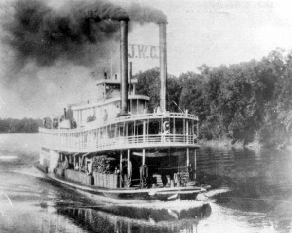
Established in the years after the War Between the States (or Civil War), it was a major riverboat port that came into existence as the local economy shifted from cotton production to naval stores and timber. Paddlewheel boats like the John W. Callahan and W.C. Bradley provided transport for these commodities.

https://twoegg.blogspot.com/2015/01/52-did-titanic-curse-sink-john-w.html
The John W. Callahan often stopped at Old Parramore
Five different riverboat landings served the growing community, providing places where paddlewheel steamboats could edge up to the bank of the Chattahoochee River to load or unload passengers and cargo. The most important of these was Peri Landing (pronounced "pea-rye"). It was located on a bend of the river just north of today's Parramore Landing Park.

A warehouse landing, Peri had storage facilities where farmers and businessmen could leave bales of cotton, timber and other cargo for the riverboats to transport either upriver to Columbus, Georgia, or downriver to Apalachicola, Florida. It holds a unique although forgotten place in local history as the eastern end of a major county road built in 1914 to connect western Jackson County with the Chattahoochee River. The steel Bellamy Bridge over the Chipola River that so many people love and remember was built as part of an upgrade associated with the building of the new road to Peri Landing.

Annual Oak Grove Homecoming at Old Parramore
Back on the high ground away from the river, the town of Parramore grew. It was centered around today's intersection of Oak Grove and Parramore Roads and at its height included at least five stores, blacksmith shop, cotton gin, sawmill, gristmill, post office and more. Large naval stores operations grew around the town, with turpentine stills operating in almost every direction. Local senior citizens recall how they could look to the horizons and see the stacks of the stills streaming black smoke into the air.

Site of Old Parramore business district today.
Railroads and modern highways eventually put the paddlewheel riverboats out of business and Old Parramore vanished with them. One by one the stores, turpentine stills and other businesses faded away. All that is left today are a couple of historic houses, a one-room school, cemeteries and the ruins of Central School.

Making hush puppies at the annual Central School Reunion
Two annual events bring the vanished town back to life each October. The annual Oak Grove Homecoming has been taking place for more than 50 years and features music, historical discussions, a brief sermon and dinner on the grounds. Each year, dozens of current and former Parramore residents and their families attend, along with those who come to learn more about the historic community.

The other event is the Central School Reunion. Former students and their families gather each year at the ruins of the historic school to remember the days of their youth.

If you would like to learn more about this significant Jackson County ghost town, please consider my book:

Old Parramore: The History of a Florida Ghost Town [Book]

Old Parramore: The History of a Florida Ghost Town [Kindle]


Wednesday, March 12, 2014

#93 Irwin's Mill Creek (100 Great Things about Jackson County, Florida)

Irwin's Mill Creek in Jackson County, Florida
Irwin's Mill Creek, a beautiful clear-water stream, is #93 on our list of 100 Great Things about Jackson County, Florida.  Please click here to see previous installments on the list.

Once called the Ekanachattehatchee or "Red Ground Creek," Irwin's Mill Creek is fed by small springs just north of the Alabama state line. It flows to the southeast through Alabama's Chattahoochee State Park and across the line into the northeast corner of Jackson County. It flows into the Chattahoochee River just north of the State Highway 2 bridge into Georgia. The nearest landing is at Neal's Landing Park.

Irwin's Mill Creek
The creek is an ecological treasure. Very few spring-fed streams flow into the Chattahoochee River and Lake Seminole, but Irwin's Mill Creek looks more like one of the beautiful spring runs that feed the Chipola River than it does one of the sloughs and backwaters of Lake Seminole. It winds through a stunning floodplain swamp and at most times of the year is so clear that the bottom is clearly visible.

Historically, it flows through one of the most significant spots in Jackson County. The famed Money Pond, which supposedly holds the treasure of the pirate and adventurer William Augustus Bowles ("Billy Bowlegs"), is near and the creek forms the northern limits of the 18th century Creek Indian town of Ekanachatte ("Red Ground"). Please click here for more on the Money Pond.

Irwin's Mill Creek
Even before the late 1700s and the time of Bowles and Ekanachatte, the creek was a major landmark.The Spanish first pushed west from Mission San Luis (present-day Tallahassee) during the 1600 to bring the Christian faith to the Chacato (or Chatot) Indians. This tribe lived between the Chipola River and Holmes Creek in western Jackson County, northeastern Washington County and southwestern Houston County, Alabama. They were closely allied with a neighboring tribe that the Spanish called the Chisca but which many researchers believe were the ancestors of the modern Yuchi.

Irwin's Mill Creek
The Yuchi today are considered by the U.S. Government to be part of the Creek or Muscogee Nation, but historically they were an independent people. They have their own language, customs, ceremonial practices and traditions. They helped incite the Chacato people to rebel against and drive out the Franciscan missionaries, an act that brought the wrath of the Spanish military down on both groups.

When the Spanish first arrived, it appears that the Chisca or Yuchi lived in a village along the banks of Irwin's Mill Creek. The fled west into Walton and Okaloosa Counties after the Chacato rebellion, but for nearly one century afterward the site of their village on Irwin's Mill Creek was known as the Chiscatalofa Old Fields. The word "Chiscatalofa" literally means Chisca Town.  A village by that name remained associated with the Lower Creeks until their removal on the Trail of Tears in the 1830s, but the original Chiscatalofa was in the northeast corner of Jackson County.

Irwin's Mill Creek
When the Red Ground Creeks arrived to establish Ekanachatte in the 1760s, they settled on the Chiscatalofa Old Fields since they were easier to clear for farming than the surrounding old grown forests.

After Ekanachatte was destroyed in 1818 and while Florida was still a Spanish colony, American settlers began to drift into the vicinity and settle on the abandoned fields of the village. Among those who established farms along what they called the "Conchatty Hatchy" were Joseph Brown, William Brown, Joseph Brooks, William Chamblis, James Irwin, Adam Kimbrough, William McDonald, William H. Pyke, George Sharp and Allis Wood.

James Irwin, one of these settlers who arrived in 1819-1820, built a dam and watermill on the creek where it crosses from Alabama into Florida. The dam and ruins of the mill still survive and represent the oldest American structural remains in Jackson County.

From that time until today, the stream has been known as Irwin's Mill Creek and it is one of the 100 Great Things about Jackson County, Florida.

Sunday, January 29, 2012

Mission San Carlos - One of the Oldest Settlements in Jackson County

West Bank Overlook near Sneads
Noted for its beautiful views of Lake Seminole, the West Bank Overlook near Sneads also holds the distinction of being one of the most significant historic sites in Jackson County. It was here during the 1680s and 1690s that the Spanish maintained the mission of San Carlos de Chacatos.

A mission was a religious center where Franciscan friars worked to convert Native Americans - in this case Chacato Indians - to Christianity.
View of Jim Woodruff Dam from the Overlook

Mission San Carlos was established in around 1680 to serve a group of Christian Chacatos that had relocated to the hilltop near Sneads from their original homes west of the Chipola River in Jackson and Washington County. A 1675 rebellion involving part of the tribe had destroyed the original Mission San Carlos, thought to have been located near Falling Waters State Park in Washington County. A sister mission, San Nicolas, was destroyed in what is now Jackson County at the same time.

Both of these original missions had been dedicated in 1674, but lasted for less than one year. Spanish soldiers and allied Apalachee warriors retaliated against the Chatot by invading their territory and destroying their towns and fields.
Lake Seminole

Not all of the Chacato had been involved in the rebellion, however, as several hundred members of the tribe had accepted Christianity through the teachings of the Franciscans. Opting to remain close to the Spanish, they relocated to the confluence of the Chattahoochee and Flint Rivers (today's Lake Seminole), where they built a new town on the high ground where the West Bank Overlook can be seen today. The site was then directly across the Chattahoochee River from Mission Santa Cruz de Sabacola, which stood in what is now Seminole County, Georgia.

In around 1680 the Franciscans responded to the calls of the Chacato and established a new Mission San Carlos at the site near Sneads. It would remain for the entire time of its existence the westernmost establishment on the Florida mission chain and the most outlying post of the King of Spain in the Florida colony.
Part of the Mission San Carlos Site

This status gave Mission San Carlos a unique place in history. In 1686, for example, Marcos Delgado left the mission on a noted overland expedition to establish an alliance with the Upper Creeks of Alabama. Seven years later in 1693, Governor Don Laureano de Torres y Ayala rested briefly at San Carlos while making the first known overland crossing of the Florida Panhandle by Europeans. Both expeditions also stopped at another well-known Jackson County landmark, Blue Springs.
Another view of the Mission Site

Mission San Carlos, tragically, did not survive the decade of the 1690s. Attacked by war parties of Creek Indians from Alabama and Georgia, the mission was destroyed. Many of its people were slaughtered and others carried away into slavery to be sold to the English in South Carolina. The church was desecrated and its religious objects either destroyed or carried away as booty.

The site of the mission was rediscovered in 1948 by Florida archaeologist Ripley P. Bullen. Working on the hilltop at the west end of the then under construction Jim Woodruff Dam, Bullen found pieces of Spanish ceramics and other artificacts indicating the presence of the mission site. The West Bank Overlook now crowns the hill where Bullen conducted his work.

There are no interpretive markers at the site noting it as the location of the long forgotten mission, but perhaps the future will bring about an effort to place one there.  To learn more about Mission San Carlos and other Spanish sites in Jackson County, please consider my book: The History Of Jackson County, Florida: The Early Years.

It is also available for Amazon Kindle by clicking here: The History of Jackson County, Florida: The Early Years

Sunday, October 2, 2011

Old Parramore marks 50th Annual Oak Grove Homecoming

Rev. Cap Pooser leads the Veterans Memorial Dedication
One of Jackson County's most unique events marked its 50th anniversary today as a crowd gathered in the ghost town of Old Parramore to celebrate the annual Oak Grove Homecoming.
Each year on the first Sunday of October, the old town comes back to life as former residents and their families gather to share memories, friendship and dinner on the grounds in what was once the heart of a thriving Chattahoochee River trading community. This year's event was the 50th such gathering and featured cannon firings, music from the Sheila Smith Trio and the dedication of a memorial to local veterans.

Memorial and Flag
Parramore grew as a significant community during the years after the Civil War due to a surge in the value of timber and turpentine products from the vast longleaf pine forests that once covered eastern Jackson County. Paddlewheel riverboats nudged up to landings at the community, providing a means of transportation for its products and commerce. The steamboat traffic sparked the growth of a thriving business community.

By the end of the 19th century, Parramore had become a signficant commercial, industrial and population center. The main business district boasted five stores, a cotton gin, sawmill, gristmill, blacksmith shop, mule lot and other businesses. Turpentine stills operated at locations surrounding the community and rafts of pine timber were floated down the Chattahoochee and Apalachicola Rivers to the shipyards at Apalachicola.

The Sheila Smith Trio
The introduction of paved highways and truck traffic in the first half of the 20th century, however, spelled the end of Parramore's days as a business center. Trucks replaced riverboats as the primary means of moving forest products and steamboat traffic on the Chattahoochee River faded away during the 1930s and 1940s. The town of Old Parramore faded away with the boats.

In 1961, however, current and former residents of the area began a tradition that continues to this day. The annual Oak Grove Homecoming at Old Parramore was initiated as a way to preserve the memory of the town and its former residents. Some of those present for today's 50th anniversary celebration were on hand for that original gathering.

Rev. Cap Pooser, Alfred Cox and James Harrell with Cannon
The annual event spurred the preservation of Oak Grove Cemetery and the adjoining site of the original Oak Grove Freewill Baptist Church as a grounds for the homecoming. A modern brick church, which opens its doors only once each year, was built at the site as a memorial to the pioneer families of the area.

So far as is known, the annual Oak Grove Homecoming is the only annual gathering at a Florida ghost town that has continued for five decades. It is a unique part of Florida culture.

To learn more about the history of the community, please consider my book: Old Parramore: The History of a Florida Ghost Town. It can be ordered on the right side of this page or as an instant download for Amazon Kindle at www.exploresouthernhistory.com/kindle. It is also available at Chipola River Book & Tea in Downtown Marianna.

Thursday, September 30, 2010

Oak Grove Homecoming at Old Parramore set for Sunday


The annual Oak Grove Homecoming will be held this Sunday (October 3rd) at Old Parramore in eastern Jackson County.

Parramore was a town that thrived from around 1885 to 1927 as a riverboat port where cargoes of lumber, turpentine, cotton, catfish and even gopher tortoises were shipped out on paddlewheel steamboats for transport up or down the Chattahoochee and Apalachicola Rivers. At its height, the community - which was never incorporated but was a town just the same - had five stores, a cotton gin, sawmill, gristmill, blacksmith shop, four turpentine stills, post office and more. Today it has been reclaimed by the pine woods.

Each year on the first Sunday in October, however, Old Parramore comes back to life. Oak Grove Baptist Church, which opens its doors only once a year, plays host to the annual Oak Grove Reunion. The gathering brings people and families with ties to the Parramore area back for conversation, a church service, dinner on the grounds and music.

This year's event will take place on Sunday and things will get started around 10 a.m. I've donated 20 signed copies of my new book, Old Parramore: The History of a Florida Ghost Town, to Oak Grove Church and they will be available for donations to the church, with 100 percent of the proceeds going to support the annual homecoming and care of the historic church and grounds.

If you can't make it to the homecoming, the book is also available through Amazon.com by following the link at left.

Wednesday, April 7, 2010

Irwin's Mill Creek was Key Area for Early Settlers

By Dale Cox


Irwin’s Mill Creek – When American settlers began drifting across the Florida line into what would become Jackson County in the years following the First Seminole War, one of the areas that immediately attracted their attention was the rich country along the south side of Irwin’s Mill Creek.

Then called Red Ground Creek, this beautiful spring-fed stream rose in the southeast corner of Alabama and flowed down across the border into the northeast corner of Jackson County. Florida was then still Spanish territory and would remain so until 1821, but to these early settlers, the opportunity offered by the high quality land was more than worth the risk of moving into a foreign country.

Several factors attracted early settlers to the area as they began to drift across the line in around 1819. First was the availability of good, clean water. Second, the creek flowed with enough force to power a watermill, one of the few industries essential to life in the early 19th century. Third, the land along the creek was very rich and ideal for farming the types of crops then popular (corn, sugar cane, cotton). Finally, the heavy forests that grew naturally across much of the region had already been cleared away.

For at least fifty years, the area of Jackson County from Irwin’s Mill Creek down to Neal’s Landing on the Chattahoochee River had been the site of the important Creek Indian village of Ekanachatte or “Red Ground.” Established before the American Revolution, this rather spread out town had been supported by fields and pastures along both the river and creek. Ekanachatte had been destroyed on March 13, 1818, during the First Seminole War and its inhabitants had relocated downriver to a new site about ten miles north of present-day Sneads.

The fields and cleared areas were empty when white settlers began to arrive, providing an excellent opportunity for them to build homes and start farming immediately without the back breaking labor of felling old growth trees to clear land.

By 1821, when Florida was ceded to the United States by Spain, Irwin’s Mill Creek had become one of the three largest early settlements in Jackson County. The others were in the Spring Creek area near Campbellton and along the Apalachicola River below Sneads.

Given the opportunity to file claims for land they had occupied while Florida was still a Spanish colony, ten Jackson County residents did so based on farms they had established along the creek between 1819 and 1821. They were Joseph Brooks, Joseph Brown, William Brown, William Chamblis, James Irwin, Adam Kimbrough, William McDonald, William H. Pyke, George Sharp and Allis Wood.

The presence of so many heads of household indicates that the Irwin’s Mill Creek settlement probably had a total population of at least 50 or 60 people.

James Irwin, one of these early settlers, built the mill that provided the creek the name by which it is known today. The ruins of his mill can still be seen and are thought to be the only surviving remains of a structure built in Jackson County while Florida was still Spanish territory.

Note: You can learn more about early settlements in The History of Jackson County, Florida: The Early Years. The book is available online at http://www.amazon.com/, where you can also find the second volume in the set, The History of Jackson County, Florida: The War Between the States.